Kokopelli’s Trail: Day One

Up until a couple of days before the big Kokopelli’s Trail ride, I wasn’t sure when it was going to happen. Balancing all of the things in my schedule, along with Pete’s and Jess’s, was looking hopeless. We planned to leave Thursday night, but I had a meeting in Denver, so even that was put on hold until about 9:00. As luck would have it, we were forecast for one of the biggest snowstorms of the season that night. Rumors were even circulating that the Vail Pass was closed, making the drive all but impossible. Fortunately, the pass was open, but the drive was still dicey. Not only was the driving tricky, but the visibility was pretty bad as well. We finally pulled into the trailhead at Loma around 2:30 a.m., just in time for a few hours of fitful sleep.
It was cold Thursday night in Fruita, but there was no sign of snow. This was a good sign, as we were slightly concerned we might encounter some snow along the high-elevation sections of the trail that passes through the Manti-La Sal National Forrest. Thanks to the accommodations in the front seat of Pete’s Jeep, I was up at first light. After some obligatory stretching, we headed off to Utah to find the Bitter Creek campground to drop some water for the next day’s ride. Getting to the camp was pretty straight forward, but we were surprised to find so many people camping out in both the middle of April and nowhere. We left two collapsible 100 oz. Nalgene® bottles of water and about 1/2 a bottle of Powerade under a tree adjacent one of the picnic tables at an unoccupied site.
By highway, it was about 20 miles back to Fruita. We made a quick side trip into town so that I could pick up a new tube for my Camelback® (I found mildew in my old one, yuck!) and a roll of TP for the trip. I also grabbed a cup of coffee that I hoped would wake me up and fuel me throughout the day’s riding. Back at the trailhead, we unpacked the bikes and started gearing up for the trip. We shuffled some of the gear, with me taking the tent from Pete. I set up the rack and panniers on my bike, and Pete adjusted his backpack. That’s right, in addition to riding to Moab, we’d also be comparing the relative merits of two rival packing systems.

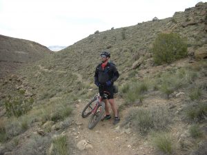
We checked the tire pressure, lubed our chains, and saddled up at about 10:30 am. I’d already ridden most of the day’s trail, but never in a single day. The extra load would be a new challenge, and I was a little concerned that the rack and panniers wouldn’t be up to the task. Kokopelli’s Trail starts with Mary’s Loop. Since I’d ridden the trail several times, I was anxious to see how things would unfold with the extra load. I was pleasantly surprised that the opening climb, a prolonged rocky section, was pretty easy. The rack made the rear-end of the bike pretty heavy, but while riding it was almost unnoticeable. In fact, the only reminders of its presence were an occasional banging noise when flying over particularly rough sections of trail and an increased difficulty in getting the back tire over large step-ups. On the flip-side, the extra weight actually added some stability in rolling large drop-offs.
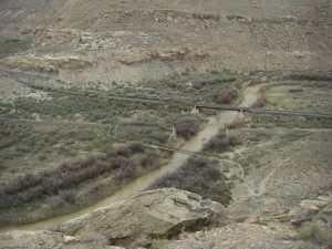
A little after noon, we reached the Salt Creek crossing. The view from above was spectacular. We decided to ride down and cross the little bridge before breaking for lunch. The bridge has two twin posts in place to stop 4-wheelers and the like from crossing. I practically needed to butter up the panniers to squeeze through, but I made it. We had a nice lunch, and I snuck off to find a bit of cover to put the morning’s final purchase to use. There is very little privacy to be found in the desert.

Just after lunch we tackled the first significant hike-a-bike section of the trail. Quickly it became clear that all of the benefits of riding with a rack and panniers were negated when trying to carry your bike over rough terrain. Pete was suffering from a sore bum due to the extra load from his backpack, but I was really struggling to haul my bike up all of the climbs and around all of the rocks. Struggling with the bike really took a lot out of me, so I was glad to reach the end of the hike. I didn’t realize at the moment how little singletrack remained, but I was glad to have smooth, rideable road the whole way into Rabbit Valley.
The Rabbit Valley trailhead was bustling with activity when we rolled in for a snack stop. Dirt bikers, ATVers, and fellow mountain bikers were seemingly everywhere. We had a nice snack, but it was getting late. We needed to get back on the bike and finish the day’s ride. This brought us to the ride’s first disagreement. In my mind, Kokopelli’s Trail was going to be 142 miles of stellar singletrack. There are two ways to ride through Rabbit Valley. One, the official trail, uses a variety of dirt roads. Some of them are pretty rough, but mostly it’s a slough through pretty sandy washes. As an alternative, there are a number of singletrack trails like Rabbit Valley #2 that mostly parallel the roads. Pete wanted to ride the official trail, but I was in favor of singletrackus maximus. That’s when I reconciled the goofy image I had of Kokopelli’s Trail with the reality that was Kokopelli’s Trail. We ended up taking the official route.

Rolling out from the trailhead, we only had about 10 miles of additional riding to reach our first campsite. We’d been averaging a pathetic 5 miles an hour (breaks and photo stops included), and some profound saddle sores were beginning to set in. Most of the remaining miles were scenically beautiful, but my mind kept drifting to the 400′ climb listed on the map. It was literally the end of the day’s ride, finishing right at the campground. When we finally got to the bottom of the climb, it became obvious that it was steep. Pete had opened up a small gap on me over the proceeding couple of miles, and I found him standing next to his bike at the base of the climb. He had already determined that he’d just walk the 1/2 mile climb, but I was determined to try and ride the whole trail. I told him it looked pretty manageable after the 2nd switchback. I’ll never know if I was right, because I lost control and had to put a foot down after an ultra-slow-speed collision with a rock. Pete caught up to me sooner than I caught my breath, and we finished walking to the plateau together.
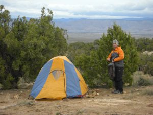
At the campground, we discovered that the water we had stashed earlier that morning was insufficient to hold the campsite. We also discovered that some of the water was missing from one of the canteens. There was another site available nearby, and the guys camping by our water replaced what they’d taken. We were shocked that someone would take some of the water, but we were way too tired to really care. We made dinner, brushed our teeth, and turned in to bed before the sun had even set. Since I’d brought the iPod, I set up an alarm for 8:00 am and put on some Cat Stevens. I don’t even remember the 2nd song.
2 Comments
EmilyBrinkman
Wait, they stole your water? In the desert?? Not cool. At least you got some coffee out of it the next morning (probably made with your water).
Pingback: